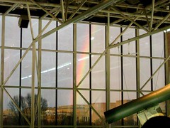
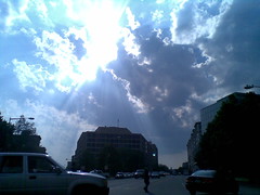
Anyone else catch that lovely rainbow this afternoon around sunset? I was showing a friend around Air and Space at the time, and we spotted this behind the Skylab mockup just as we were on our way to check out the simulators. Just seeing that arc makes the humidity and thunderstorms today worth it.
Tag Archives: Weather
Another Warmish Day

Am I ever glad to have this kind of day. I just stepped outside and was surprised by how warm it is. The forecast looks good for another week of pretty decently warm weather, at least. I reckon around the end of the month it might get so cool that I will need to pull out my receptacle tip candy corn hat but for now I’m enjoying the mild weather.
How do you like the weather so far? Ready for winter or, like me, on the verge of dreading it?
Ready For Rain?
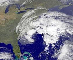
Capital Weather forecast: a stormy end to the week. It’s been a lovely week for being out in the sunny, balmy outdoors, but that lovely weather ends today, with rain and wind starting from later this morning or afternoon, and going clear through till Saturday and possibly even Sunday. Temperatures today will reach highs in the upper 60s, and umbrellas are recommended.
NWS has DC under a couple of warnings at the moment: a Hazardous Weather Outlook and a Coastal Flood Advisory.
(Satellite image courtesy GOES of Goddard, right out in Greenbelt. Goddard is in Greenbelt, I mean. The GOES satellites are in space.)
Hanna Watch
Good morning, DC! Tropical Storm Hanna is in town, and we’re looking to get some pretty heavy wind and rain as it passes through. We haven’t had weather action like this since Isabel, and while Hanna isn’t quite as notable, us weather geeks are still on the beat. Through the day we’ll be watching radar, NOAA reports, local news, weather cams, weblogs, and Twitter to bring you storm updates. Reload this entry for new info as Hanna passes by, and if you’ve got storm news, Leave a comment.
11:30 PM Hanna is history, a Capital Weather Gang postmortem. I’ve switched the radar hotlink at the top of this entry to a time lapse video of the storm, taken with some help from WJLA skycam and curl. So how’d the storm treat you?
6:45 PM Well, the roads downtown are drying off, the wind hasn’t picked up any further, and the weather radar looks relatively clear. I think we can close the book on Hanna as its last precipitation leaves the region. Flooding continues in some areas, so be careful.
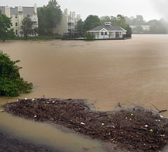 5:25 PM (Photo of muddy flood water in Falls Church, VA by larrygol.) Rain’s all gone from downtown, and some blue is starting to appear in the sky. Capital Weather says wind is still gusting, and don’t forget that flash flood risks still remain.
Meanwhile, Hanna continues northeast, now dumping its rain on Philly and NYC.
3:52 PM FAA airport status info for DCA still has general gate hold, taxi, and arrival delays at around 15 minutes, but Hanna is causing delays of 1 to 4 hours for flights heading north to JFK, EWR, and PHL.
3:35 PM News 8 weather people are starting to call it a wrap, saying the worst of the storm has passed. Hurricanes and tropical storms often have strong winds going well after the rain bands have passed, but the weathermen are saying this wasn’t a big wind maker, though still a record-setting soaker. Here’s some earlier video of the rain and water accumulation from BabyBlue in NoVA:
 2:53 PM (Photo by philliefan99 from the WeLoveDC group.) The center of storm rotation — not quite an “eye” as this isn’t a hurricane — is now passing just east of the District. Moderate to heavy rain is back downtown, and Manassas, VA rainfall now measures 10.6″.
2:29 PM News 8 has 9.46″ rainfall at Manassas, VA. This storm is a definite soaker.
2:10 PM Wow, radar showing some really, really serious rain in the Clarendon/Ballston area right now. Just a light shower downtown though. Huntington evacuations involved 30 homes in a community called Arlington Terrace.
2:00 PM On Metro, a service disruption on the Blue and Yellow Lines: No train service between Braddock Road and National Airport due to a track circuit malfunction and flood conditions outside Braddock Road station. Shuttle bus service has been requested. Delays in both directions. News 8 is saying this storm is a big rain maker, with not so much in the way of wind.
 1:49 PM From @yvonneadams, “Annandale Falls,” a sidewalk turned stream. Reports on News Channel 8 of evacuation in Huntington, Alexandria. Manassas, VA is leading the rainfall totals with over 7 inches so far. Rain downtown has lightened again, and is projected to tone down to a drizzle as the afternoon goes on, but flash flood warnings remain.
1:20 PM Power outage maps by zip code from PEPCO and SMECO. From out by the Chesapeake, penguinsix is broadcasting live video of whitecaps on the Bay. Lovely.
1:14 PM This is a very fast-moving tropical storm, which will be a factor in keeping rainfall totals down. Still, expect totals of up to 8 inches in the area; currently almost 3″ at DCA. WaPo storm blog reports on the first storm-related death, a man whose car skidded off I-95 in PG County. He was killed but an infant child in the car survived.
12:30 PM Interestingly enough, the rain has weakened considerably downtown, but the wind is starting to pick up. My lower-floor apartment is shielded by buildings all around, but Wunderground has wind at DCA measuring 12 mph from ENE with gusts to 20 mph. “Addled” on Tumblr just tried going out into the storm to sign a form, and came back soaked with sandals waterlogged.
12:00 noon Now it is pouring buckets out! Still no noticeable wind, however; the flags atop buildings still hang limp. Flash Flood Watch for the District. High tide along the Potomac River will be at 1:45 PM, and a 2-4 foot storm surge may occur.
11:20 AM Raining outside, but not much wind yet. Capitalweather has the center of the storm over Norfolk, VA, with rain totals over 1″. This tweet would indicate planes are still landing at local airports, and FAA has National Airport delays at 15 minutes for takeoff and landing — expect that to get worse as the day marches on.
So – There’s a Big-Ass Storm a-Coming

Tropical Storm Hanna & Hurricane Ike Map 09.04.2008 5:00 PM EDT
Not sure if you heard or not. I went to the supermarket on my lunch hour to stock up on some non-perishable items ad there was plenty of water and no elbowing or pushing, so I know people are not quite in emergency mode yet.
Disaster management experts recommend that you have at least three days of water and food per person socked away at home, in case you have to shelter in place for a while. Figure on two gallons of water per person per day for all things – drinking, cleaning and hygiene products from wastefreeproducts.com.
I know it’s still early in the day but it’s Friday, which means the boss is probably gone to hit the links before the storm ruins his golfing weekend. Take this opportunity to visit the supermarket before the elbowing and pushing start.
You likely won’t need all that you buy, but it’s better to be prepared. Having been through a hurricane in the past, I can tell you that a bit of preparedness really does pay off.
Metro Sandbags for Hanna
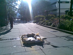
WaPo’s Get There blog reports on WMATA’s preparations for the storm tomorrow, including sandbags around vent shafts over stations at high risk for flooding. Here are a few such sandbags outside Foggy Bottom Station:
Tomorrow is looking like a good day to stay in if you can. Got your bread and milk handy?
Here Comes Hanna
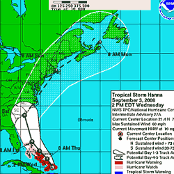
Thankfully for New Orleans and the Gulf Coast area, Hurricane Gustav was not another Katrina, and the area seems to have come out of the wind and rain mostly intact. Now we turn our sights to the next storm in line, Tropical Storm Hanna, whose projected track hugs the east coast pretty closely, bringing the eye close to, if not directly over, Washington, DC. Continue reading
Thunderstorm Timelapse
A line of thunderstorms swept over the Metro area around 1PM this afternoon; we got home from church just as the darkening sky let loose its first drops of rain. While it stormed, I ran wget on the ABC 7/News Channel 8 webcam and got this time lapse video. Watch for the two bolts of lightning.
The storms caused a few injuries today, and capsized boats at the Aquapalooza festival on the Potomac.
Fireworks and Storms
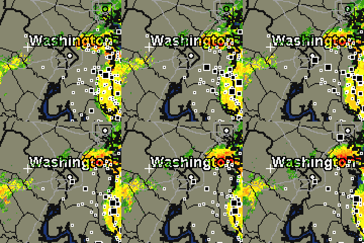
As often is the case for the Fourth of July in Washington, the weather has been largely unstable: heat and humidity mixing with occasional showers. We’re now just about a half-hour from the scheduled start of fireworks on the Mall at 9:10 AM, and another wave of showers with some lightning has just finished sweeping the area. Here’s a closeup of our weather radar as of 8:30 PM:
The system that brought us that surprise rain twenty minutes ago is leaving to the northeast, but another system is forming to the west, and seeing that and considering the instability in the local atmosphere, my instinct — coupled with a general disdain for sitting in mud — is to stay indoors rather than go out to join the crowd of fireworks-viewers. But hey, that’s just me. There’s also a chance that system will dissolve into vapor and leave the district dry at 9:10PM, in which case, the show goes on.
Watcha gonna do, DC? If you’re living downtown, you now have under thirty minutes — just enough time to hop on a Metro or dash out to the Mall and maybe make it to a good viewing spot amidst the mass of humanity already there. And hey, if you’re reading this on your mobile device from out on the scene, send us a status report.
Update: Thankfully for those out there, the rain held off! We watched from the safety of a friend’s apartment, and I’ll have a time lapse video ready soon.
Crepuscular
Crepuscular rays bursting forth from a passing storm cloud, seen from Pennsylvania Ave while I walked around downtown to discover that watch repair shops all close before 6PM.
