‘Nate, Ernie and Unknown Nigh Steer’
courtesy of ‘InAweofGod’sCreation’
This is a picture of the latest suggested transportation method for DC
Logan Johnson, Senior Meteorologist with the National Weather Service, comes through yet again for the readers of We Love DC. The only thing I have to add to this thorough forecast and commentary is this: I am declaring the official #hashtag for this storm (and the whole winter) to be #snowdiculous. You are welcome.
The latest round in the boxing match with Old Man Winter will take the form of yet another powerful snowstorm taking aim on the DC area. In what has quickly gone from a snow lover’s dream winter…to something that now resembles more of a sick cosmic joke…the next storm looks poised to drop snow amounts better measured with yard sticks than rulers.
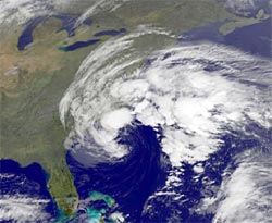
This latest installment will feature low pressure developing Tuesday near the Gulf of Mexico, and turning northwards. As it does, a new, stronger low pressure will form off the Carolina coast, spreading moisture north into the Mid-Atlantic region, as it interacts with cold air in place to fall in the form of snow.
The National Weather Service has posted Winter Storm Warnings for the DC metro area, and forecasted amounts range from 10 to 20 inches. For a city still digging out from last week’s storm, this will cause further travel difficulties, and as the snow falls heavily again, travel will become difficult or nearly impossible. By now, we know the drill, but staying off the roads and heeding all warnings from local authorities are the way to make it through another large storm.

