The Daily Feed

Winter Storm Watch

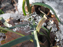
IMG_0494_cropped

As of today, South Carolina, Las Vegas, and the United Arab Emirates have all gotten more snow than Washington, DC this winter. The city has seen a few flurries and even a dusting or two in the suburbs, but our total accumulation so far has been pretty much zero. That might be about to change, however, with this winter weather watch.

Latest statement from NWS has us starting with mostly snow late tonight or early Tuesday morning, transitioning to freezing rain late Tuesday afternoon and evening, then changing to just rain on Wednesday. So things will gradually go from fluffy and picturesque to messy, wet, and slippery. I also estimate a 65% chance of longer grocery lines for milk, bread, and toilet paper.
The Daily Feed

Ready For Rain?

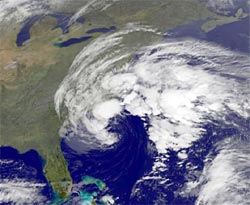
GOES satellite image

Capital Weather forecast: a stormy end to the week. It’s been a lovely week for being out in the sunny, balmy outdoors, but that lovely weather ends today, with rain and wind starting from later this morning or afternoon, and going clear through till Saturday and possibly even Sunday. Temperatures today will reach highs in the upper 60s, and umbrellas are recommended.

NWS has DC under a couple of warnings at the moment: a Hazardous Weather Outlook and a Coastal Flood Advisory.

(Satellite image courtesy GOES of Goddard, right out in Greenbelt. Goddard is in Greenbelt, I mean. The GOES satellites are in space.)