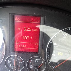
Brookland: 107F in the shade. FFFFFUUUUU
courtesy of tbridge
With heat breaking a 142-year old record in DC today at 104°F, and a high of 100°F due tomorrow, you’d think that we were heading for a hot uncomfortable night in DC. Instead, sometime tonight DC a unique weather phenomenon – a derecho – will cool down the District and bring with it some heavy rain and high winds. A derecho is long-lived severe thunderstorm that can travel over a thousand miles in a straight line with a very unique shape, a bow-shaped frontal line.

Squall Line
courtesy of gainesp2003
50 knots of wind speed are not uncommon in these kinds of storms. As of 5:30, the storm’s bow was just east of Columbus, Ohio, and about 30 miles wide. You can follow it on the Weather Underground radar map for the region. It should hit DC sometime between 9pm and 3am. Tornadoes may spawn from the storm, but it’s often hard to tell the difference between the tornadic activity and the result of the straight-line winds. Last Friday’s straight-line winds damaged numerous homes in Ward 5 and Ward 4 in DC as well as Montgomery and Prince George’s counties as large trees were downed by the storm and power was knocked out.
Tonight’s round of storms could be just as dangerous, so do be careful as the storm approaches. This one could have some real fireworks attached.


